Flores II
Sustainable and Integrated Management of Mbeliling Forest, Flores, Indonesia. Phase II, 2011-2015.

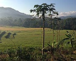
Landscape in Werang Village, West Flores.
Objective
The objective of the project is to improve livelihoods in communities in the Mbeliling area through participatory forest management and through the development of existing and new sources of income, empowerment of the local communities and ensuring their participation in the decision making process at the district level.
Project area
The Project area is located in the western most part of the island of Flores in the District of West Manggarai in East Nusa Tenggara, one of the poorest provinces in Indonesia and the province with the fifth lowest Gross Regional Domestic Product (GRDP) in the country.
The Mbeliling forest area is located between 400–1,200 meters above sea level. The two primary habitats in Mbeliling area are semi-evergreen tropical rainforest and tropical deciduous forest, which has the highest priority for biodiversity conservation in tropical areas. The forest resources in the project area are not contributing as they should to poverty reduction, economic and social development, and environmental sustainability. Instead, many forest areas are threatened with degradation, fragmentation and destruction. Forest loss undermines rural livelihoods, ecosystem services, and Indonesia’s ability to meet poverty alleviation goals.
The total number of inhabitants in the 27 villages in the project area is approx. 34,000 individuals distributed in a total of 7,000 households. Overall, the population of Mbeliling is a marginalised and vulnerable group due to the poverty level, the low food security, and poor access to public services in the area.

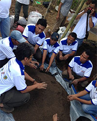
Training Course in Natural Resource Management - practical exercise.
Capacity building
The main activity area of the project is capacity building, related to forest management and management of natural resources, for the communities living in the Mbeliling area.
Through capacity build and collaboration with the district authorities the local communities will be directly involved in and responsible for major of management of the forests in and around the project area. Community development groups are established in the 27 villages being responsible for the local involvement in an integrated landscape oriented planning and management of the forest- and other natural resources in the areas.
IGN's Research Group on Tropical Trees and Landscapes is given the task to provide input to the project in all forestry related matters, and thereby support and ensure the forestry component of the project contributing to the conservation and income generation purposes of the project.
Main activities
The inputs from IGN/Research Group on ‘Tropical Trees and Landscapes’ focus on the following main activities:
- Support to integrated Landscape Approach in the natural resource management and planning process at village and district level.
- Support to provision of inputs to village development groups based on application.
- Training courses in TOT and technical subjects (sustainable management of forest, planting of trees, nursery management and other areas).
- Technical support to the establishment of local seed stands/cum conservation stands of 3-5 priority species, training and field practice.
- Technical support to the establishment of demo plots and arboretums.
- Practical training in establishing and management of village nurseries.
- Identification of long term conservation and research needs.
The project is implemented by Dansk Ornitologisk Forening (DOF)/Birdlife Denmark through a donation from Danida amounting to 9.5 Million DKK.
The inputs from IGN are financed through a contract with DOF of 1.1 million DKK.
