
Potential Natural Vegetation of South-Western and Central Kenya
A tool for the selection of indigenous tree species
 In many areas in the tropics with high human population pressure, original forest cover has disappeared as farmland replaces forests. Although many farmers practice agroforestry and grow trees on their farms, agricultural landscapes are dominated by exotic species whereas densities of indigenous tree species have declined drastically.
The decline in coverage of indigenous tree species in human-dominated landscapes is accompanied by lack of ecological knowledge of where these species can be grown.
There is a growing interest of farmers, local governments and NGOs to grow indigenous tree species to provide timber, fruit, watershed protection, biodiversity and other services previously provided by forests. But information on tree species for certain areas has not been readily available - that is, until now.
Scientists in East Africa have found a solution to this problem. Ecologists Roeland Kindt, Paulo van Breugel and Jens-Peter B Lillesø lead a team that adapted old vegetation maps into easy-to-use decision support tools to help identify the best indigenous trees to grow on farms.
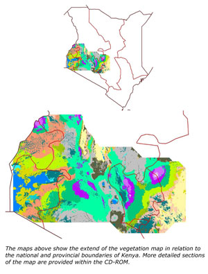
The team first studied detailed maps developed earlier by Trapnell and other researchers. These showed the vegetation cover in the Lake Victoria Basin and central Kenya in the 1960s. The team then developed new maps (later printed at a scale of 1:300,000) showing the original vegetation cover of the entire area. Next, they compiled species lists for each of the original vegetation types and obtained information on potential functions of each species from databases, literature and herbarium specimens from the East African Herbarium.
Here you find the documentation, maps a selection of the species and resources for "Potential natural vegetation of south-western and central Kenya".
For you to get the full information you can require the CD "Potential natural vegetation of south-western and central Kenya" from Roeland Kindt r.kindt@cgiar.org
Documentation
Provides documentation on how the potential natural vegatation maps and species lists were obtained
- Short documentation (pdf)
- Detailed information: Part I (pdf)
- Detailed information: Part II (pdf)
Map Sheets
Provides eletronic versions of the potential natural vegetation map
- Learn how to determine the vegetation type of your area of interest (pdf)
- Map sheet 1 (pdf)
- Map sheet 2 (pdf)
- Map sheet 3 (pdf)
- Map sheet 4 (pdf)
Species
Provides lists of indigenous tree species for potential natural vegetation types and summary and detailed information for a subset of the listed species
- Learn how to select tree species with the SpeciesSelector spreadsheet (pdf)
- SpeciesSelector (MS Excel)
- Find out for which species fact sheets are available (pdf)
- Example of one of the 207 species descriptions obtained from the book on Useful Trees and Shrubs for Kenya (pdf Adenium obesum)
- Example of one of the 122 species descriptions obtained from AgroForestTree database (pdf Prunus africana)
- Example of one of the 21 species descriptions obtained from Seed Leaflets series from the Danish Center for Forest and Landscape (pdf Faidherbia albida)
Extra Resources
Provides some of the materials that were compiled for the Tree Seeds for Farmers - toolkit, including all the chapters of the manual
- Tree Seeds for Farms manual (pdf)
- Tree Seeds Management field manual (pdf)
- Short guidelines for collecting tree seeds (pdf)
- Short guidelines for ordering tree seeds (pdf)
- Short guidelines for multiplying tree seeds (pdf)
- Guide to handling of tropical and subtropical forest seed
- Good tree nursery practices: practical guidelines for community nurseries
Publications
The geographic designations employed and the presentation of materials in this publication do not imply the expression of any opinion whatsoever on the part of the World Agroforestry Centre concerning the legal status of any country, territory, city or area or its authorities, or concerning the delimitation of its frontiers or boundaries.
If this is the first time that you are using this material, then we suggest that you follow the following steps to open the various documents that are provided:
2. Based on the instructions, determine which of the four map sheets you want to consult.
3. Based on the instructions, determine which of the three mapping formats (PDF or interactive htm) you want to consult
4. Open the map sheet in the preferred format from the MapSheets folder (some links are provided below).
- Map sheets in PDF format are available from the MapSheets\PDF folder or via links provided below.
- Map sheets in interactive htm format are available from the MapSheets\Interactive folder or via links provided below.
6. Read the instructions on how to identify and select tree species that are suitable for a particular vegetation type.
For you to get the full information you can require the CD "Potential natural vegetation of south-western and central Kenya" from Roeland Kindt r.kindt@cgiar.org
You can use the following citations:
Kindt R, Lillesø J-P B, van Breugel P, Nzisa A, Orwa C, Graudal L, Jamnadass R and Nyabenge M. 2008. Potential natural vegetation of south-western Kenya for selection of indigenous tree species: CD-ROM with electronic versions of the map, species selection tool and detailed descriptions for a subset of species. Nairobi: World Agroforestry Centre. ISBN 978-92-9059-223-5.
Kindt R, Lillesø J-P B, van Breugel P and Nyabenge M. 2005. Potential natural vegetation of south-western Kenya for selection of indigenous tree species: sheets 1 - 4. Nairobi: World Agroforestry Centre.
Kindt R, van Breugel P and Lillesø J-P B. 2007. Use of vegetation maps to infer on the ecological suitability of species using central and western Kenya as an example. Part I: Description of potential natural vegetation types for central and western Kenya. Landscape Development and Environment Series no. 6-2007. Hørsholm: Danish Centre for Forest, Landscape and Planning and Nairobi: World Agroforestry Centre. 67p.
Kindt R, van Breugel P and Lillesø J-P B. 2007. Use of vegetation maps to infer on the ecological suitability of species using central and western Kenya as an example. part II: Tree species lists for potential natural vegetation types. Forest and Landscape Development and Environment Series no. 7. Hørsholm: Danish Centre for Forest, Landscape and Planning and Nairobi: World Agroforestry Centre. 77p.
Since the original vegetation map was published by CG Trapnell together with different co-authors and at different times, pick the correct citation based on the map sheets that you used:
Trapnell CG, Birch WR and Brunt MA. 1966. Kenya 1:250,000 Vegetation Sheet 1. Results of a vegetation – land use survey of south-western Kenya. British Government’s Ministry of Overseas Development (Directorate of Overseas Surveys) under the Special Commonwealth African Assistance Plan
Trapnell CG, Birch WR, Brunt MA and Lawton RM. 1976. Kenya 1:250,000 Vegetation Sheet 2. Results of a vegetation – land use survey of south-western Kenya. British Government’s Ministry of Overseas Development (Directorate of Overseas Surveys) under the Special Commonwealth African Assistance Plan
Trapnell CG, Brunt MA, Birch WR and Trump EC. 1969. Kenya 1:250,000 Vegetation Sheet 3. Results of a vegetation – land use survey of south-western Kenya. British Government’s Ministry of Overseas Development (Directorate of Overseas Surveys) under the Special Commonwealth African Assistance Plan.
Trapnell CG, Brunt MA and Birch WR. 1986. Kenya 1:250,000 Vegetation Sheet 4. Results of a vegetation – land use survey of south-western Kenya. British Government’s Overseas Surveys Directorate, Ordnance Survey under the UK Government’s Technical Co-operation Programme
Trapnell CG and Brunt MA. 1987. Vegetation and climate maps of south-western Kenya. Land Resources Centre, Tolworth Tower, UK, 9 pp.
Please cite the reference materials with species descriptions as follows:
Maundu P and Tengnas B. 2005. Useful trees and shrubs for Kenya. Nairobi: World Agroforestry Centre. 484 pp.
Simons AJ, Salim AS, Orwa C, Munjuga M and Mutua A. 2005. Agroforestree database: a tree species reference and selection guide. Version 3.0 CD-ROM. Nairobi: World Agroforestry Centre. URL >http://www.worldagroforestry.org/NurseryManuals/Community.htm<
(Please check for information on citation from each Seed Leaflet separately.)
Please cite the extra resource materials on tree seeds as follows:
Dawson I and Were J. 1997. Collecting germplasm from trees: some guidelines. Agroforestry Today, 9 (2): 6–9.
Dawson I and Were J. 1998. Multiplication, that’s the name of the game: guidelines for seed production of agroforestry trees. Agroforestry Today, 10 (4): 19–22.
Dawson I and Were J. 1998. Ordering tree seed: some guidelines. Agroforestry Today, 10 (1): 8–11.
Jaenicke H. 1999. Good tree nursery practices: practical guidelines for research nurseries. Nairobi: International Centre for Research in Agroforestry. 90 pp.
Kindt R, Lillesø J-P B, Mbora A, Muriuki J, Wambugu C, Frost W, Beniest J, Aithal A, Awimbo J, Rao S, Holding-Anyonge C. 2006. Tree Seeds for Farmers: a Toolkit and Reference Source. Nairobi: World Agroforestry Centre.
Mulawarman, Roshetko MJ, Singgih MS and Djoko I. 2003. Tree seed management – seed sources, seed collection and seed handling: a field manual for field workers and farmers. Bogor: Winrock International and World Agroforestry Centre. 54 pp.
Schmidt L. 2002. Guide to handling of tropical and subtropical forest seed. Humlebaek: DANIDA Forest Seed Centre.
Wightman K.E. 1999. Good tree nursery practices: practical guidelines for community nurseries.
Nairobi: World Agroforestry Centre. 95 pp.
Sponsors
The Vegetation Maps Project was supported by the Flemish Association for Development Cooperation and Technical Assistance (VVOB) through the Testing Options and Training Partners in Participatory Tree Domestication and Marketing in East Africa (TOTDOMEA) project in collaboration with the Danish Centre for Forest and Landscape Planning.
Contact
For you to get the CD "Potential natural vegetation of south-western and central Kenya" and
further information contact
Roeland Kindt r.kindt@cgiar.org
World Agroforestry Centre
