
Turbulence and sediment transport initiative (TASTI)
THE PROJECT IS FINISHED
Project period: From 2015 to 2019.
The general aim of the project is to resolve the question how and why sand is transported onshore to feed beaches. This requires a description of the magnitude and intra-wave phasing of sand suspension due to both breaker-induced and bed-generated turbulence.
The intertidal instrument array.
The aim of this project is to resolve a long standing question in the disciplines of coastal morphodynamics and engineering: How and why is sand transported onshore in the natural surf zone during low-moderate energy conditions? Since field studies in coastal geomorphology were initiated in the 1930’s and 40’s, it has been known that beaches undergo continuous cyclic changes of erosion and accretion. During stormy periods, beaches erode and sand is transported offshore from the beach and into the surf zone. Conversely, intervening fair-weather conditions are associated with onshore transport of sand, and beaches accrete again. Without this fair-weather onshore sand transport, beaches would not exist.
Hydrodynamic and sandy sediment
Hydrodynamic and sandy sediment transport processes occurring during high-energy stormy conditions are fairly well known and can be modelled with a reasonable degree of confidence. Sand is suspended into the water column by spilling surf bores and is then carried offshore by steady currents, termed undertow. The process is sufficiently straightforward for sediment transport models to simulate using statistical parameters and time-averaged quantities and such models are incorporated into current model complexes that predict sand transport and beach morphological change (Xbeach; Delft 3D, MIKE21).
This level of insight and modeling skill does not apply to conditions when beaches accrete. Presently available sediment transport models are incapable of simulating onshore sand transport and thus beach recovery under natural conditions with confidence. The main reason is that in such cases, sand transport is dominated by non-steady oscillatory rather than steady flows. This means that intra-wave time scales and processes become important, the resolution of which requires an investigative approach that is wave-phase-resolving rather than time- or phase-averaging. It is these time scales and processes that the project will investigate during periods of onshore sand transport using wave-phase-resolving analytical techniques to understand and model the phase relationships between the (oscillatory) flow and the sediment load.
Sediment mobilisation
Sediment mobilisation depends on turbulence injection from both breaking waves and from fluid interaction with the (irregular) seabed. Model parameterization of diffusivity due to breaking waves has mostly been ignored or led by results from laboratory experiments. Recent work has shown, however, that in the real world, surface-injected turbulence may indeed reach the seabed and stir the sediment and indications are that near-bed sediment diffusivity may be severely underestimated in models. The timing of turbulence injection into the water column is critical to an understanding and parameterization of intra-wave sediment transport. Turbulence is also derived from interaction between the fluid and a rough seabed, particularly when bedforms exist. Several bedform types have been identified in nature and they likely affect sediment suspension and timing in different ways but these ways have not been quantified and have not been introduced in either time-averaged or phase-resolving sediment transport models. Hence, a proper understanding and ultimately modelling of onshore sand transport requires a more complete understanding of the timing (with respect to wave phase) and magnitude of both surface- and bed-generated turbulence and the way that these turbulence sources affect sand mobilization.
In contrast to earlier field studies, the project aims to combine measurements of both near-bed turbulence, its vertical structure, and the vertical distribution of suspended sediment load, including the very-near bed region, complemented with measurements of nearshore bedforms inside the surf zone and the project revolves around two hypotheses:
- Near-bed sediment diffusivity in a natural surf zone is dominated by breaker-induced turbulence when waves are plunging and bed-generated turbulence when this is not the case. The relationships are constrained by sediment grain size that affects bedform steepness.
- The absolute and relative magnitude of the two turbulence sources and their phase relationship with the oscillatory wave motion determine – in combination with sediment grain size/bedform steepness - total suspended sand load and the direction and magnitude of intra-wave sand transport.
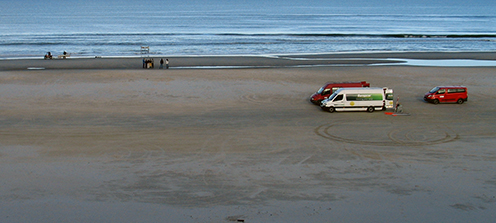
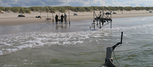
The first field measurements were collected at the beach of Vejers on the west coast of Denmark, which is dominated by energetic short-period wind waves and occasionally low swell waves. The median grain size is 180 µm. Two instrument rigs, specifically designed to study the effect of surface-induced turbulence on sand suspension and transport beneath breaking waves, were equipped with vertical arrays of acoustic current meters (ADVOcean probes and ADVF’s), optical backscatter sensors (UFOBS and OBS), ripple profilers, profiling and imaging sonars and pressure sensors. They were (initially) deployed on the seaward flank of an intertidal bar, 15 m apart in the cross-shore direction, as part of a cross-shore array extending from -1 m to 1 m above mean sea level. This array further contained five individual pressure sensors and two smaller rigs, each with a vertical array of three OBSs, an Electromagnetic Flow Meter (EMF) and a pressure sensor. An alongshore array of five additional pressure sensors were installed to measure alongshore differences in the wave field over the intertidal beach.
At the start of the campaign the beach profile contained an intertidal bar, which steepened and moved onshore under low energy conditions (H0=0.4-0.8 m) during the first ten days of the experiment (Figure 1). During days 11, 12 and 13 of the experiment, relatively high energetic conditions (H0 up to 4.0 m) resulted in the disappearance of the intertidal bar (Figure 1, dashed line). During subsequent low energetic swell (H0<1 m) from day 14 until day 23, an intertidal bar was reformed and migrated onshore.
The hydro- and morphodynamics during the TASTI experiment thus allowed us to collect a unique dataset, including two periods with an onshore migrating and steepening intertidal bar.
 day 2, (solid) day 10, (dashed) day 14 and (dotted) day 23; the last day of the campaign. The red symbols on the initial profile represent the location of the (squares) turbulence rigs and (triangles) the smaller transport rigs.")
Figure 1
The cross-shore profile at the location of the instrument array on (thick line) day 2, (solid) day 10, (dashed) day 14 and (dotted) day 23; the last day of the campaign. The red symbols on the initial profile represent the location of the (squares) turbulence rigs and (triangles) the smaller transport rigs.
TASTI-TOO
The TASTI-TOO field campaign was held in September 2017 at Durras Beach, NSW, Australia. Durras is exposed to a different wave climate compared to Vejers; the waves are typically easterly and southeasterly swells originating in the Southern Ocean and the grain size in the surf zone is 0.30-0.45 mm which is significantly coarser than at Vejers. One instrument frame was mounted at Durras holding vertical arrays of acoustic current meters and (fibre)optical backscatter sensors in addition to profiling and imaging sonars and pressure sensors.

Wave conditions during the experiment were relatively calm – as planned for – although an energetic swell event with 3 m waves occurred within the first few days. Accordingly, the beach face first eroded, followed by beach accretion during the later stages driven by low swell, but occasionally interrupted by wind waves with shorter periods due to onshore sea breezes.
t; Tp = peak spectral wave period (red line)) recorded by the Waverider buoy at Batemans Bay. An energetic swell event (Hs = 3 m, Tp = 12 s) occurred shortly after instrument deployment.")
Depending on wave and tides, the position of the instrument frame ranged from the innermost surf zone/lowermost swash zone at low tide, to the shoaling wave zone at high tide. Turbulence and sediment suspension were therefore recorded under a wide range of wave conditions including non-breaking waves, plunging and spilling breakers, and inner surf zone bores. Analysis of the comprehensive data set is ongoing on a wave-by-wave basis.


Dr Troels Aagaard, associate professor
Institute of Geosciences and Natural Resources
University of Copenhagen, Denmark; project coordinator.
Dr Gerben Ruessink, professor
epartment of Physical Geography, Utrecht University
The Netherlands.
Dr Michael Hughes,
University of Sydney and NSW Office and Environment and Heritage
Australia.
Dr Verner B. Ernstsen, associate professor
Institute of Geosciences and Natural Resources
University of Copenhagen, Denmark.
Drude F Christensen, PhD student at the University of Copenhagen.
Joost Brinkkemper, PhD student at the Department of Physical Geography, Utrecht University, The Netherlands.
Funding
The project is funded by the Danish Natural Sciences Research CouncilProject
Turbulence and sediment transport initiative (TASTI)
Project manager
Troels Aagaard
Associate professor
Department of Geosciences and Natural Resource Management, Section of GeographyPhone: +45 353-22511, E-mail: taa@ign.ku.dk
From 2015 to 2019