CLIMACCESS
Climate Change Resilience in Urban Mobility
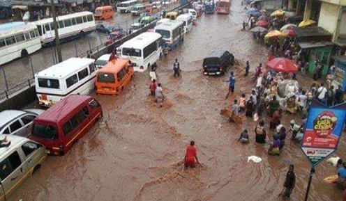
The CLIMACCESS project presents a comprehensive research effort towards a better understanding of the links between climate change scenarios, urban accessibility and the mobility of urban residents in the Accra region.
Through an interdisciplinary approach, our team of Ghanaian and Danish partners investigates the physical and human factors that determine the impacts of climate change on mobility and accessibility, with the aim of developing strategies for increasing climate change resilience within urban mobility in the Ghanaian capital.

The Climate Change Resilience in Urban Mobility (CLIMACCESS) project is a collaborative Danida supported research project involving the University of Copenhagen, University of Ghana and the Council for Scientific and Industrial Research (CSIR) of Ghana. The project span is 5 years (March, 2018—December, 2022).
OBJECTIVES
The project is to establish a comprehensive understanding of the physical and human factors that determine resilience to climate change impacts on mobility and accessibility in Accra. Specifically, the research and capacity building should lead to reduced inequality in access to mobility and, thereby, reduced vulnerability of local communities challenged by unsustainable spatial development practices and increased frequency of extreme weather events. Three Ph.Ds are be sponsored by the project.
METHODOLOGY
The project will apply a combination of quantitative and qualitative methods to address the objectives of the different work packages. The quantitative methods include questionnaire surveys, computerized analy-sis of local and city-wide elevation models, satellite images as well as GIS-based analysis of the urban transport networks in terms of risk of flooding, connectivity and level of redundancy. A small UAV “drone” will be applied to collect local elevation data for evaluation purposes. A city-wide elevation model based on satellite images will be obtained for the project. The qualitative methods include focus groups, key informant interviews, field observations, in-depth qualitative interviews and partici-patory community workshops.
MOBILITY
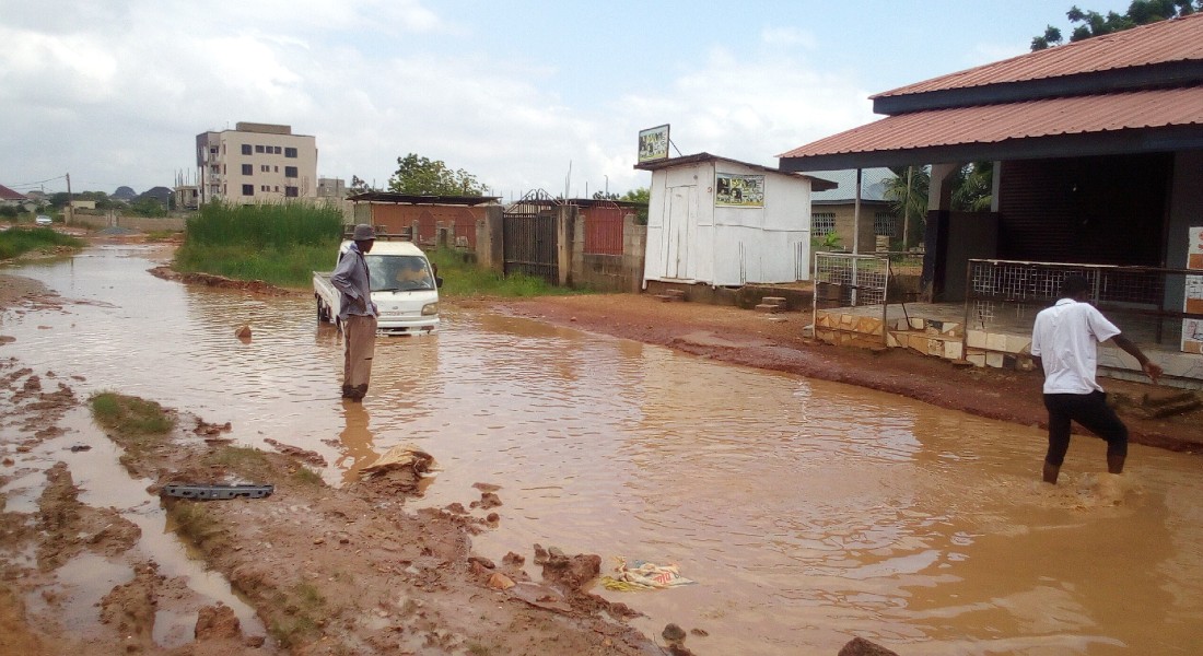
Mobility within the urban areas is a basic need for urban residents because of the strong links between mobility and livelihood. Mobility-constraints due to climatic conditions have a number of consequences, including reducing access to work places, markets and services. The expected consequences of climate change are increased levels and frequency of flooding, impacting an urban transport system which is already challenged by poor road conditions and congestion, as well as by the very rapid spatial expansion of the city.
Work package A: Urban mobility patterns, livelihood strategies and vulnerability.
Work package B: Scenarios of climate change and urban flooding
Work package C: Transport network analysis: Impact of flooding on urban accessibility and mobility
Work package D: Towards a comprehensive understanding of the interplay between climate change, urban accessibility and the mobility of urban residents.
Read more about the work packages here
PAPERS
Møller-Jensen, L., Allotey A.N., Kofie R.Y. and Yankson, P.W.K. (2020):
A Comparison of Satellite-Based Estimates of Urban Agglomeration Size for the Accra Area.
International Journal of Geoinformation, 9(2):79, January 2020. Link to paper.
Trepekli, K., Balstrøm, T., Friborg, T., Fog, B., Allotey, A.N., Kofie, R.Y. & Møller-Jensen, L. (2022):
UAV-borne, LiDAR-based elevation modelling: a method for improving local-scale urban flood risk assessment.
Natural Hazards 22-3-2022. https://doi.org/10.1007/s11069-022-05308-9.
Andreasen, M.H., Agergaard, J., Møller-Jensen, L., Oteng-Ababio, M. & Yiran, G.A.B. (2022):
Mobility Disruptions in Accra: Recurrent Flooding, Fragile Infrastructure and Climate Change. Sustainability 2022, 14. Link to paper
Møller-Jensen, L., Agergaard, J., Andreasen, M.H., Kofie, R.Y, Yiran, G.A.B. & Oteng-Ababio, M. (2022):
Probing political paradox: Urban expansion, floods risk vulnerability and social justice in urban Africa.
Journal of Urban Affairs 2022, DOI: 10.1080/07352166.2022.2108436
Andreasen, M. H., Agergaard, J., Kofie, R. Y., Møller-Jensen, L., & Oteng-Ababio, M. (2022): Urban encroachment in ecologically sensitive areas: Drivers, impediments and consequences. Buildings and Cities, 3(1), pp. 920–938. https://doi.org/10.5334/bc.210
Andreasen, M.H., Agergaard, J., Allotey, A.N.M., Møller‑Jensen, L. and Oteng‑Ababio, M. (2022):
Built‑in Flood Risk: the Intertwinement of Flood Risk and Unregulated Urban Expansion in African Cities. Urban Forum. Link to paper
Møller-Jensen, L., Allotey, A.N.M., Kofie, R.Y and Yiran, G.A.B. (2023):
How Does Flooding Influence Intra-Urban Mobility? The Case of Accra. Sustainability 15. Link to paper
Oteng-Ababio, M., Agergaard, J., Møller-Jensen, L and Andreasen, M.H. (2024):
Flood risk reduction and resilient city growth in sub-Saharan Africa: searching for coherence in Accra's urban planning. Front. Sustain. Cities, 6, 2024. Link to paper
Yiran, G.A.B., Oteng-Ababio, M., Allotey, A.N.M., Kofie, R.Y. and Møller-Jensen, L. (2024):
Spatial Analysis of Exposure of Roads to Flooding and Its Implications for Mobility in Urban/Peri-Urban Accra.
ISPRS Int.J.Geo-Inf, 13, 111, 2024. Link to paper
Kofie, R.Y, Allotey, A.N.M., Møller-Jensen, Lasse and Yiran, G.A.B (2024):
A geospatial perspective of flood risk hotspots, transport networks and emergency response services in Accra, Ghana. Dan. J. Geography, Routledge, 2024. Link to paper
Balstrøm, T., Hasholt, B., Allotey, A.N.M. and Gyekye, P.M. (2024):
The Identification of Flood-Prone Areas in Accra, Ghana Using a Hydrological Screening Method. GeoHazards, 2024, 5. Link to paper
Andreasen, M.H., Agergaard, J.,Oteng-Ababio, M. & Møller-Jensen, L., (2024):
High mobility lifestyles: Unpacking travel behavior in Accra's rapidly expanding periphery. Cities, 155, 2024. Link to paper
Agergaard, J, Møller-Jensen, L, Andreasen, M.H., Yiran, G. & Oteng-Ababio, M., (2024):
Unpacking the drivers and effects of localized flooding in Glefe (Accra) and residents’ autonomous adaptation strategies. African Geographical Review, Dec. 2024. Link to paper
METHODOLOGY REPORTS
Methods for analyzing the mobility impacts of urban flood events
30. December 2020. Ver. 1.2
Accra Flood Modelling - Workflow documentation, 2. December 2020
PROJECT REPORTS
Kick-off Workshop Report 27. June 2018
Influence of climate change on the future precipitation pattern in the region of Ghana
31. January 2019
Workshop Report: The Role Of Emergency Response During Floods In Accra. 17. August 2022
Report on the Dissemination and Outreach Workshop, African Regent, Accra, 15th November, 2023
PUBLICATIONS
Conference publications
IGN working paper - settlement reports
Urban expansion and consolidation in Accra’s peripheries: An examination of development and flood risk in four settlements. IGN Working Paper Series, December 2020
Policy briefs and popular science description
Flooding in Accra: Between ineffective spatial planning and climate change. Climaccess Policy Brief No 1, May 2021
Flooding in Accra: Implications for intra-urban mobility. Climaccess Policy Brief No 2, Jan. 2024
End of project popular science description. May 2024
PhD course reports
PhD course report by Prince Martin Gyekye,
August 2020
Master thesis reports
PRESENTATIONS
Introduction to the Inception Workshop27. June 2018.
NADMO presentation for Inception Workshop 27. June 2018.
Urban mobility patterns, livelihood strategies and vulnerability27. June 2018.
How can local risk of flooding be analysed using drones?27. June 2018.
Stormwater screening of Accra.27. June 2018.
How may we indentify flood-prone areas from city-wide terrain models?18. August 2018.
CLIMACCESS presentation at open-day (CSIR-INSTI)20. September 2018.
CLIMACCESS presentation at CSIR-INSTI workshop. 18. October 2018.
Consistency in Remote Sensing-based Urban Mapping for Growth and Mobility Analysis.15. October 2019.
Impact of urban expansion on livelihoods in Accra. G. Yiran. 10. Nov 2021.
"Every time it rains": Navigating recurrent flooding, fragile infrastructure and associated mobility disruptions in Accra’s periphery. Presentation at the AAG conference March 23-27 2023. Link
Climate change-related risks in Metropolitan Accra: Is Glefe [in]visible to adaptation? Presentation at the AAG conference March 23-27 2023. Link
Identifying storm water prone locations in Accra, Ghana from a 1D hydrologic modelling validated by UAV-LiDAR. Presentation at the AAG conference March 23-27 2023. Link
Hotspots of flood-induced mobility constraints in Accra. Presentation at the AAG conference March 23-27 2023. Link
Flood-induced mobility disruptions. Presentation at Nordic Geographers Meeting. June 2024. Link
High-mobility lifestyles. Presentation at Nordic Geographers Meeting. June 2024. Link
List of community dissemination workshops. Link
LINKS TO EXTERNAL PUBLICATIONS
Arc-Malstrøm: A 1D hydrologic screening method for stormwater assessments based on geometric networks
Thomas Balstrøm and David Crawford, Computer and Geosciences vol 116, July 2018.
Hans kælder stod under vand efter et kraftigt skybrud: Så fik forskeren en lys idé
BlueSpot maps with extent and depth values can be found on the Climaccess Flood Risk Portal
-- Updated maps 12-08-2024 (refer also to Climaccess paper):
1. Bluespot filling events and stream runoff at 60 mm rain event
2. Bluespot depths (m) at 60 mm rain event
3. Bluespots Streams Pour-points Watersheds
4. Extent of bluespots at a 60 mm rain event if clogging prevents runoff
Maps showing impact of floods on urban mobility can be found on the Climaccess Mobility Portal
Other maps created by the project can be found on the Climaccess Geodata Portal
|
|
|
|
Paul Yankson, DGRD until February 2021 |
|
|
|
|
|
|
|
|
|
 |
|
Albert Allotey, CSIR |
|
|
|
|
 |
|
 |
|
 |
|
|
Katerina Trepekli, DGN |
 |
|
Abubakari Abdallah, PhD student |
 |
|
|
 |
|
Stephen Yao, PhD student |
 |
Follow research activities, read about new publications and view project news on the News and Acitivities page.
List of community dissemination workshops here.

Funding

![]()
The project is funded by Danida/FFU with DKK 9.8 mill.
Project Period: March 2018 – December 2023


