
The Sermilik Scientific Research Station
The Sermilik Scientific Research Station provides a logistic base for the ongoing glaciological, hydrological and geomorphological investigations of the Mittivakkat Glacier and its catchment.
The Sermilik Research Station is located at 65º 40' N and 38º 10'W in South East Greenland about 20 km north of the small town Tasiilaq (Ammassalik). The station is situated at the coast in the Sermilik Fjord on the west side of the island Ammassalik adjacent to a local small ice cap, the Mittivakkat Glacier.
Based on monitoring data from the Mittivakkat glaciated catchment back from the early 1990th models have been developed to test future scenarios and present hind casts and forecasts of response to climate change.
The emphasis of research project is on the control of climate on landscape processes, on different elements of energy and water balances, hydrology and sediment transport and on proglacial weathering. Furthermore geomorphology, polysequent soil profiles, niveo aeolian sediments, and sedimentary archives from lakes, polysequent soils and sediments form fluvial, estuarine and near coastal environments are studied to elucidate the Holocene climate, vegetation dynamics and environmental history, focussing on the late Holocene, the period after the culmination of The Little Ice Age and on present Global Change.
During an expedition in 1933 led by the famous polar researcher Knud Rasmussen the first surveys of glaciers and geomorphology were carried on Ammassalik Island and at the Mittivakkat Glacier. Because of this mapping, the Mittivakkat Glacier catchment was chosen as one of the Danish research sites during the International Geophysical Year in 1957-1958. At that time the glacier terminus had retreated 0,6 km. since 1933. In 1970 a permanent field station, The Sermilik Research Station, was established, to provide a logistic base for the ongoing glaciological, hydrological and geomorphological investigations of the Mittivakkat Glacier and its catchment. In 1990 an "Arctic Physical Geographical Research Group" was formed at the Department of Geography and a comprehensive "Arctic System Science Research and Monitoring Project" was planned, leading to the establishment of automated climate and river measuring stations in the catchment. After 2000, datasets from The Sermilik Research Station have been used in modelling, distributing and simulating climate, snow cover, snow and glacier melt, run off and sediment transport in the Mittivakkat Glacier catchment. Models have further been used to forecast the effect of global warming using IPCC and HIRHAM predicted scenarios.
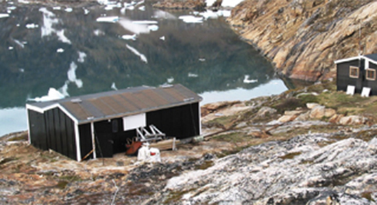
The Sermilik Research station can be used year-round. However the climate and the logistic constraints during the winter months makes the summer period June -September the obvious high season for field research. The fjord adjacent to the station is ice covered during December-May. The main building is an insulated wooden house of 60 m2 with three rooms for scientists, a dining room, a living room, a kitchen, a toilet and a storage room. A second, nonisolated building of 50 m2 holds workshop, equipment, generator, a zodiac rubber boat as well as optional accommodation for four persons in a separate room. A small separate building holds fuel storage and additional equipment. An annex facility (a 6 m2 wooden building) is situated on a small nunatak at the equilibrium line of the Mittivakkat Glacier 515 m.a.s.l. The annex supports the monitoring activities on the glacier and can be used for accommodation during field work. The station buildings allow the accommodation of 6-10 researchers. During student summer field courses a tent camp is established at the station.
Publications based on research and data from The Sermilik Research Station 1959-2010
1959
Valeur, H. (1959): Runoff studies from the Midtluagkat Gletscher in SE-Greenland during the late summer 1958. Geografisk Tidsskrift/Danish Journal of Geography 58: 209-219.
1960
Fristrup, B. (1960): Studies of Four Glaciers in Greenland. Geografisk Tidsskrift/Danish Journal of Geography 59: 89-102.
1970
Fristrup, B. (1970): A New Geographical Station in Greenland. Geografisk Tidsskrift/Danish Journal of Geography 69: 199-203.
1976
Hasholt, B. (1976): Hydrology and transport of material in the Sermilik area 1972. Geografisk Tidsskrift/Danish Journal of Geography 75: 30-39.
1980
Hasholt, B. (1980): Morphological and hydrological possibilities for the development of water power at Angmassalik - A case study of applied physical geography. Geografisk Tidsskrift/Danish Journal of Geography 80: 57-62.
Petersen, L. & Rasmussen, K. (1980): Mineralogical composition of the clay fraction of two fluvio-glacial sediments from East Greenland. Clay Minerals 15(2): 135-145.
Master Field Course Report (1980): Report from an arctic field course in physical geography at the Sermilik Research Station, 1979. Department of Geography and Geology, University of Copenhagen.
1984
Hasholt, B. (1984): Undersøgelser af nedbørsfordelingen i Grønland. Hydrologi og Vandkvalitet. Nordisk Hydrologisk Konference NHK-84 (1): 299-310.
1986
Hasholt, B. (1986): Kortlægning af Mitdluagkat Gletscheren og nogle hydro-glaciologiske observationer. Geografisk Tidsskrift /Danish Journal of Geography 86: 9-16.
1988
Hasholt, B. (1988): Massbalance studies of the Mitdluagkat Glacier, Eastern Greenland. Geografisk Tidsskrift /Danish Journal of Geography 88: 82-85.
1990
Jakobsen, B.H. (1990): Soil formation as an indication of relative age of glacial deposits in Eastern Greenland. Geografisk Tidsskrift /Danish Journal of Geography 90: 29-35.
1992
Hasholt, B. (1992): Sediment transport in a proglacial valley, Sermilik, East Greenland. Geografisk Tidsskrift/Danish Journal of Geography 92: 105-110.
Hasholt, B. & Walling, D.E. (1992): Use of caesium-137 to in¬vestigate sediment sources and sediment delivery in a small glacierzed mountain drainage basin in eastern Greenland. In: Erosion, Debris Flows and Environment in Mountain Regions, IAHS Publ. 209: 87-99.
1993
Hasholt, B. (1993): Late autumn runoff and sediment transport in a proglacial drainage system, Sermilik, East Greenland. Geogra¬fisk Tidsskrift/Danish Journal of Geography 93: 1-5.
Jacobsen, A., Carstensen, A.R. & Kamper, J. (1993): Mapping of satellite derived albedo on the Mitdluagkat Glacier, Eastern Greenland, using a digital elevation model and SPOT HRV data. Geogra¬fisk Tidsskrift/Danish Journal of Geography 93: 6-18.
1994
Nielsen, N. (1994): Geomorphology of a degrading Arctic delta, Sermilik, Ammassalik Island, South-East Greenland. Geogra¬fisk Tidsskrift/Danish Journal of Geography 94: 46-56.
Hasholt, B. (1994): Sermilikstationen, en feltstation på Grønlands sydøstkyst. Tusaat, 4: 27-29.
Humlum, O. (1994): Forskning ved Sermilikstationen. Tusaat, 4: 33-35.
1995
Christiansen, H.H. (1995): Nivation forms, processes and sediments in recent and former arctic areas. Ph.D. thesis. Department of Geography and Geology, University of Copenhagen, 1995.
1996
Busskamp, R. & Hasholt, B. (1996): Coarse bed load transport in a glacial valley, Sermilik, South East Greenland. Zeitschrift für Geomorphologie 40: 349-358.
Hasholt, B. (1996): Sediment Transport in Greenland. Erosion and Sediment Yield - Global and Regional Perspectives. Proceedings of the Exeter Symposium, July 1996. IAHS Publication 236: 105-114.
1998
Master Field Course Report (1998). Report from an arctic field course in physical geography at the Sermilik Research Station, 1998. Department of Geography and Geology, University of Copenhagen.
1999
Christiansen, H.H., Murray, A.S., Mejdahl, V. & Humlum, O. (1999): Luminescence dating of Holocene geomorphic activity on Ammassalik Island, SE Greenland. Quaternary Geochronology 18: 191-205.
Knudsen, N.T. & Hasholt, B. (1999): Radio-echo Sounding at the Mittivakkat Gletscher, Southeast Greenland. Arctic, Antarctic, and Alpine Research 31: 321-328.
Asmussen, J. (1999): Gletscheres indre dræningssystem generelt og anvendelsen af en geokemisk metode til undersøgelse af en østgrønlandsk gletschers indre dræningssystem i slutningen af ablationsperioden. Matser thesis. Department of geography and Geology, University of Copenhagen, 1999.
2000
Hasholt, B., Walling, D.E. & Owens, P.N. (2000): Sedimentation in arctic proglacial lakes: Mittivakkat Glacier, south-east Greenland. Hydrological Processes 14: 679-699.
Hasholt, B. (2000): Evidence of a warmer climate around AD 600, Mittivakkat Glacier, South East Greenland. Geografisk Tidsskrift/Danish Journal of Geography 100: 88-90.
Hasholt, B. (2000): Grønland som leverandør af sediment til de omgivende have. In Topografisk Atlas Grønland: 128-130. Det Kongelige Danske Geografiske Selskab.
Hasholt, B. (2000): Sermilikstationen. In Topografisk Atlas Grønland. 184-185. Det Kongelige Danske Geografiske Selskab.
Hasholt, B. & Hansen, B.U. (2000): Ammassalik - Vind og Vandkraft. Topografisk Atlas Grønland: 326-329. Det Kongelige Danske Geografiske Selskab.
Dissing, L. (2000): Studier af kemiske forhold i sne aflejret på og ved Mittivakkat-gletscheren i Østgrønland. Master thesis, Department of Geology, University of Aarhus, 2000.
Karlsen, H.G. (2000): Terrænkorrigeret energibalance i et arktisk landskabved Mittivakkat-gletscheren i Østgrønland. Master thesis, Department of Geology, University of Aarhus, 2000.
Dissing, L. (2000): Studier af kemiske forhold i sne, aflejret på og ved Mittivakkat-gletscheren i Østgrønland. Master thesis, Department of Geology, University of Aarhus, 2000.
2001
Hasholt, B., Liston, G.E. & Knudsen, N.T. (2001): Snow Distribution Modelling in the Ammassalik Region, South East Greenland. 13th Northern Researh Basins International Symposium & Workshop. Saariselkä, Finland: 291-307.
2002
Hasholt, B. (2002): Measuring calving in Icefall Lake, SE Greenland, using a "Diver" pressure transducer with a built-in datalogger. Geografisk Tidsskrift/Danish Journal of Geography 102: 77-81.
Lang, A. (2002): Hydrology on the Ammassalik Island. Master Thesis, Geografisk Institut, Københavns Universitet.
2003
Hasholt, B., Liston, G.E. & Knudsen, N.T. (2003): Snow-Distribution Modelling in the Ammassalik Region, South East Greenland. Nordic Hydrology 34(1/2): 1-16.
Hasholt, B. & Hagedorn, B. (2003): Hydrology, geochemistry and Sr isotopes in solids and solutes of the Mittivakkat Gletscher, SE-Greenland. Proceedings of the 14th NRB Symposium, August 25-29, 2003: 49-57.
Knudsen, N.T. & Hasholt, B. (2003): Mass balance observations at Mittivakkat Gletscher, Southeast Greenland 1995-2002. Proceedings of the 14th NRB Symposium, August 25-29, 2003: 77-84.
Hasholt, B. (2003): Method for estimation of the delivery of sediments and solutes from Greenland to the Ocean. IUGG meeting Sapporo, July 2003, IAHS Publications 279: 1-9.
Vejrup, J.T. (2003): Datering af Mittivakkat Gletscheren, Ammassalik Ø, Østgrønland.
Master thesis, Department of Geology, University of Aarhus.
2004
Hasholt, B. & Mernild, S.H. (2004): Estimation of water balance at the Mittivakkat Glacier Basin, Ammassalik Island, South East Greenland - preliminary results. Workshop "Synthesis of Water Balance Data from Northern Experimental Watersheds" Victoria, Canada March 15-19, 2004: 1-13.
Callaghan, T.V., Johansson, M., Heal, O.W., Sælthun, N.R., Barkved, L., Bayfield, N., Brandt, O., Brooker, R., Christiansen, H.H., Forchhammer, M., Høye, T.T., Humlum, O., Järvinen, A., Jonasson, C., Kohler, J., Magnusson, B., Meltofte, H., Mortensen, L., Neuvonen, S., Pearce, I., Rasch, M., Turner, L., Hasholt, B., Huhta, E., Leskinen, E., Nielsen, N. & Siikamäki, P. (2004): Environmental Changes in the North Atlantic Region: SCANNET as a collaborative approach for documenting, understanding and predicting changes. Ambio Special Report 13: 39-50
Hasholt, B., Hansen, B.U., Humlum, O. & Mernild, S.H. (2004): Meteorological stations at the Sermilikstation, South East Greenland: physical environment and meteorological observations 2002. Geografisk Tidsskrift/Danish Journal of Geography 104(2): 106-109.
Knudsen, N.T & Hasholt, B. (2004): Mass balance observations at Mittivakkat Gletscher, Southeast Greenland 1995-2002. Nordic Hydrology 35(4): 381-390.
Hasholt, B. & Hagedorn, B. (2004): Hydrology, geochemistry and Sr isotopes in solids and solutes of the Mittivakkat Gletscher, SE-Greenland. Nordic Hydrology 35(4): 369-380.
2005
Master Field Course Report (2005). Report from an arctic field course in physical geography at the Sermilik Research Station, 2005. Department of Geography and Geology, University of Copenhagen.
Mernild, S.H., Hasholt, B. & Hansen, B.U. (2005): Meteorological observations 2003 at the Sermilik Station, Ammassalik Island, Southeast Greenland. Geografisk Tidsskrift/Danish Journal of Geography 105(2): 49-56.
Hasholt, B. (2005): The sediment budgets of arctic drainage basins. IAHS publication 292: 48-57.
Mernild, S. H. & Hasholt B. (2005): Climatic control on river discharge simulations from the Mittivakkat Glacier Catchment, Ammassalik Island, SE Greenland. In proceedings of 15th International Northern Research Basins Symposium and Workshop Luleå to Kvikkjokk, Sweden, 29 Aug. 2 Sept. 2005: 141-164.
Hasholt, B., Bobrovitskaya, N., Bogen, J., MacNamara J., Mernild, S., Milburn, D. & Walling, D.E. (2005): Sediment transport to the Arctic Ocean, a review. In proceedings from the 15th International Northern Research Basins Symposium and Workshop Luleå to Kvikkjokk, Sweden, 29 August 2 September, 2005: 43 p.
Hasholt, B. (2005): Snowmelt report. Sequence of recordings of the Mittivakkat proglacial river taken from automatic camera station.
Mernild, S. H. & Hasholt B. (2005): Climatic control on river discharge simulations from the Mittivakkat Glacier Catchment, Ammassalik Island, SE Greenland. Poster ICARP II WG7 Copenhagen 10-12 November 2005.
Mernild, S.H., Liston, G.E., Hasholt, B. & Knudsen, N.T. (2005): Snow Distribution and Melt Modeling for Mittivakkat Glacier, Ammassalik Island, Southreat Greenland. Poster ICARP II WG7 Copenhagen 10-12 November 2005.
2006
Mernild, S.H. (2006): Freshwater discharge from the coastal area outside the Greenland Ice Sheet, East Greenland. With focus on Mittivakkat, Ammassalik Island, (Low Arctic) and Zackenberg (High Arctic). PhD thesis, COGCI, Institute of Geography, University of Copenhagen.
Hasholt, B. & Mernild, S.H. (2006): Glacial erosion and sediment transport in the Mittivakkat Glacier catchment, Ammassalik Island, southeast Greenland, 2005. IAHS Publication 306: 45-55.
Mernild, S.H. & Hasholt, B. (2006): Climatic control on river discharge simulations, Mittivakkat Glacier catchment, Ammassalik Island, SE Greenland. Nordic Hydrology: 327-346.
Mernild, S.H., Hasholt, B. & Liston, G.E. (2006): Water flow through Mittivakkat Glacier, Ammassalik Island, SE Greenland. Geografisk tidsskrift/Danish Journal of Geography 106(1): 25-43.
Mernild, S.H. (2006): The internal drainage system of the lower Mittivakkat Glacier, Ammassalik Island, SE Greenland. Geografisk Tidsskrift/Danish Journal of Geography 106(1): 13-24.
Mernild, S.H., Liston, G.E., Hasholt, B. & Knudsen, N.T. (2006): Snow Distribution and Melt Modeling for Mittivakkat Glacier, Ammassalik Island, Southeast Greenland. Journal of Hydrometeorology 7: 808-824.
Mernild, S.H., Hasholt, B. &Hansen, B.U. (2006): Meteorological observations 2004 at the Sermilik Station, Ammassalik Island, Southeast Greenland. Geografisk Tidsskrift/Danish Journal of Geography 106(1): 131-140.
Hasholt, B., Bobrovitskaya, N., Bogen, J., MacNamara J., Mernild, S., Milburn, D. & Walling, D.E. (2005): Sediment transport to the Arctic Ocean and adjoining cold oceans. Nordic Hydrology 37(4): 413-432.
Yde, J.C., Hasholt, B. & Knudsen, N.T. (2006): Sermilik Stationen - en vigtig udpost til forståelsen af klimaændringer. Geologisk Nyt 1(06): 16-19.
2007
Hasholt, B. (2007): Sermilikstationen - En arktisk feltstation. Geografi 2006: 44-47. Det kongelige Danske Geografisk Selskab. Årsskrift 2006.
Mernild, S.H. (2007): Freshwater runoff fron Eastern Greenland 1997-2005 and 2071-2100.
Proceedings of the Seventh International Conference on Global Change: Connection to the Arctic (GCCA-7), 19-20 February 2007, Faibanks, Alaska.
Mernild, S.H., Hasholt, B., Hansen, B.U. & Knudsen, N.T. (2007): Climate, glacier mass balance and freshwater runoff 1993-2005, and in a 106 years perspective, Mittivakkat Glacier catchment, Ammassalik Island, SE Greenland. Proceedings, 16th International Northern Research Basins Symposium and Workshop: 90-109.
Mernild, S.H., Hasholt, B., Hansen, B.U. & Jakobsen, B.H. (2007): Meteorological observations 2005 and in a longer perspective at the Sermilik Station; Ammassalik Island, Southeast Greenland. Geografisk Tidsskrift/Danish Journal of Geography 107(2): 59-67.
2008
Mernild, S.H., Kane, D.L., Hansen, B.U., Jakobsen, B.H., Hasholt, B. & Knudsen, N.T. (2008): Climate, glacier mass balance and runoff (1993-2005) Mittivakkat Glacier catchment, Ammassalik Island, SE Greenland, and in a long term perspective (1898-1993). Hydrology Research 39(4): 239-256.
Hasholt, B. & Jakobsen, B.H. (2008): 75 years of research at the Sermilik Station: 1933-2008, Geografisk Tidsskrift/Danish Journal of Geography 108(1): 1-4.
Humlum, O. & Christiansen, H.H. (2008): Geomorphology of the Ammassalik Island, SE Greenland. Geografisk Tidsskrift/Danish Journal of Geography 108(1): 5-20.
Jakobsen, B.H., Fredskild, B. & Pedersen, J.B.T. (2008): Holocene changes in climate and vegetation in the Ammassalik area, East Greenland, recorded in lake sediments and soil profiles. Geografisk Tidsskrift/Danish Journal of Geography 108(1): 21-50.
Hasholt, B. & Mernild, S.H. (2008): Hydrology, sediment transport and water resources of Ammassalik Island, SE Greenland. Geografisk Tidsskrift/Danish Journal of Geography 108(1): 51-72.
Hasholt, B., Krüger, J. & Skjernaa, L. 2008: Landscape and sediment processes in a proglacial valley, the Mittivakkat Glacier area, Southeast Greenland. Geografisk Tidsskrift/Danish Journal of Geography 108(1): 97-110.
Knudsen, N.T. & Hasholt, B. (2008): Mass balance observations at Mittivakkat Glacier, Ammasalik Island, Southeast Greenland 1995-2006. Geografisk Tidsskrift/Danish Journal of Geography 108(1): 111-120.
Mernild, S.H., Liston, E., Kane, D.L., Knudsen, N.T. & Hasholt, B. (2008): Snow, runoff, and mass balance modeling for the entire Mittivakkat Glacier (1998-2006), Ammassalik Island, SE Greenland. Geografisk Tidsskrift/Danish Journal of Geography 108(1): 121-136.
Knudsen, N.T., Nørnberg, P., Yde, J.D., Hasholt, B. & Heinemeier, J. (2008): Recent marginal changes of the Mittivakkat Glacier, Southeast Greenland and the discovery of remains of reindeer (Rabgufer tarandus), polar bear (Ursus maritimus) and peaty material. Geografisk Tidsskrift/Danish Journal of Geography 108(1): 137-142.
Hansen, E.S. (2008): The application of lichenometry in dating of glacier deposits. Geografisk Tidsskrift/Danish Journal of Geography 108(1): 143-152.
Mernild, S.H., Hasholt, B., Jakobsen, B.H. & Hansen, B.U. (2008): Meteorological observations 2006 and ground temperature variations over 12-year at the Sermilik Station, Ammassalik Island, Southeast Greenland. Geografisk Tidsskrift/Danish Journal of Geography 108(1): 153-162.
Toft, A.M. (2008): Arealændring af gletschere på Ammassalik Ø. Bac. Thesis. Department of Geography and Geology, University of Copenhagen.
2009
Hansen, E.S. & Hasholt, B. (2009): Radial growth of twenty-two epilithic species over five years at the Mittivakkat Glacier, Ammassalik Island, South-East Greenland. Diversity of Lichenology, 100: 123-136.
Master Field Course Report (2009). Report from an arctic field course in physical geography at the Sermilik Research Station, 2009. Department of Geography and Geology, University of Copenhagen.
Jakobsen, B.H., Hasholt, B. & Mernild, S.H. (2009). 75 års forskning ved Sermilikstationen i Østgrønland. Geografisk Orientering, Særnummer, december 2009: 14-17.
Mernild, S. H., & Jakobsen, B. H. (2009). Indlandsisen, den smeltende kæmpe - et billede af årsagerne i for-, nu- og fremtid. Tidsskriftet Grønland: 4: 2-12.
2010
Mernild, S.H. and Liston, G.E. (2010): The influence of air temperature inversion on snow melt and glacier surface mass-balance simulations, SE Ammassalik Island, SE Greenland. Journal of Applied Meteorology and Climate (in press).
Mernild, S. H., G. E. Liston, I. M. Howat, Y. Ahn, K. Steffen, B. H. Jakobsen, B. Hasholt, B. Fog, and D. van As (2010). Freshwater flux to Sermilik Fjord, SE Greenland. The Cryosphere Discussion, 4, 1-30.
Mernild, S. H. and G. E. Liston (2010). The influence of air temperature inversion on snow melt and glacier surface mass-balance simulations, SW Ammassalik Island, SE Greenland. Journal of Applied Meteorology and Climate, vol. 49(1): 47-67.
Mernild, S. H., N. T. Knudsen, B. H. Jakobsen, and B. Hasholt (2010). Gletschere på voldsom skrump. Aktuel Naturvidenskab: nr. 4: 21-23.
From Tasiilaq to the station boat or helicopter charter is recommended depending on weather, snow or ice conditions and amount of luggage/cargo. It is possible to reach the station by foot (15-20 km). Booking of favourable flight tickets is recommended ½ year in advance and travel time to the station will be 1-2 days from Copenhagen normally with a stop-over in Iceland. One day is normally spent in Tasiilaq before and after each visit to the station, to handle cargo, food and fuel. Hotel accommodation or rented rooms are available in Tasiilaq.
Mean annual temperature: -1.7 ºC
Mean temperature in January: -7.5 ºC
Mean temperature in July: 6.4 ºC
Mean annual precipitation: 984 mm
Mean annual precipitation days: 120
Mean annual sunshine hours: 1374
The environment in the SE sector of Greenland is low arctic maritime and presently experiencing pronounced changes. The regional temperatures, the cyclonic influence from lower latitudes and the impact of the Irminger Current are changing. The region is warming and consequently the Inland Ice and local glaciers are melting back. Increasing amounts of calving ice from Inland Ice outlet glaciers, among these the Helheim Glacier, are influencing the Sermilik Fjord.The vegetation of the area, situated in a low arctic coastal vegetation zone, demonstrates large flora diversity. It is dominated by dwarf shrub heaths, snow bed communities, and open fell-field communities. Fens, herb slopes and copses are present but are only found as smaller niches in the alpine dominated landscape.
The town Tasiilaq, with its approx. 1700 inhabitants of a total population in East Greenland of about 3000, is located 20 km south of The Sermilik Research Station. Tasiilaq is the largest city in East Greenland, and the city is scenically located on the Ammassalik Island at the outer coast in a local fjord surrounded by high mountains. A small river flows through the city. The Ammassalik Island and valleys behind the town have a unique flora and is a popular place for hiking.
Only about 100 years ago, the first Europeans came to the area, and the traditional Inuit culture still has a major role in daily life. But Tasiilaq is also a modern community, and the Internet and mobile phones have reached Tasiilaq. Fishing, hunting, service industries and tourism dominate. In 2004 a water power plant was constructed and put to use. 1,2 MW are produces, covering most of the electricity needed in the town.
Data on plant and lichen performance exist, including the application of lichenometri in dating of glacial deposits.
Data are available on request from:
Three climate stations: at the glacier equilibrium line (515 m.a.s.l. established in 1994)), at the coast (established in 1998) and at about 200 m.a.s.l. (established in 2009), comprising data on Si, temperature, RH, wind (direction and speed) and precipitation.
River stations: established in the mid 1990th in the proglacial valley, close to the glacier front and at the river mouth, comprising data on stage, discharge, temperature, conductivity and suspended sediment concentration.
Glacier mass balance measurements and glacier surveys carried out since the mid 1980th . Delta surveys carried out since 1989.
Maps, digital 3D terrain models, satellite data and aerial photography. Furthermore a bibliography is available, of publications arising from research at The Sermilik Research Station.
Contact
For booking of the Sermilik Station contact:
Aart Kroon, Professor
ak@ign.ku.dk