
Farmlands feature greater woody cover than savannas in semi-arid West Africa
More people equal more trees in semi-arid West Africa - A study lead by IGN published in Nature Geoscience questions ‘received wisdom’ as concerns the relationship between human agency and woody vegetation of West Africa. The scientists demonstrate that in low-rainfall areas woody cover is denser in cultivated areas than in savannas, and close to settlements rather that further away, thus rejecting simplistic Malthusian ideas of a negative relationship between population density and woody cover.

Trees in cultivated fields in Mali. Photo Martin Brandt IGN
These findings challenge the traditional view on agricultural expansion in semi-arid lands and this has implications for the understanding of effects of agricultural expansion on ecosystem services, including carbon sequestration. Also, these findings throw light upon the process of land degradation/desertification which contradicts commonly believed narratives on human expansion in drylands causing fuel-wood crisis, deforestation, soil depletion, erosion and desertification.
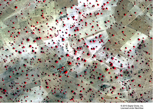
Very high spatial resolution data example showing single trees as red objects. Satellite Photo: NASA
The study is part of an unprecedented NASA project, which aims at applying commercial DigitalGlobe satellite imagery with a spatial resolution of 50 cm to map the size of each individual tree and shrub in African dryland ecosystems. The IGN team around Rasmus Fensholt and Martin Brandt was the first group outside of NASA who had access to thousands of these images, and this study is the first allowing a wall-to-wall map of woody cover based on individual trees.
In contrast to traditional case studies prone to sampling errors and bias by the prevailing societal discourse, the woody cover map includes 40,000 villages, passing a technical tipping point in dryland environmental research.
Read More
Article in Nature Geoscience
Further read in Nature Geoscience News (summary by Niall Hanan)
Contact
Martin Stefan Brandt
Postdoc
E-mail: mabr@ign.ku.dk
Phone: + 45 35 33 43 61
Mobile: 23 91 42 48
Rasmus Fensholt
Professor
E-mail: rf@ign.ku.dk
Phone.: +45 35 32 25 26
Anette Bill-Jessen
Kommunikationskoordinator
E-mail: anbj@ign.ku.dk