
Geophysics
The geophysics group at IGN is dedicated to understanding the solid earth at different time- and spatial-scales. We use a combination of observational geophysics combined with theory and modeling to understand the physical processes responsible for everything from large plate tectonics to shallow near surface processes that affect our daily lives. At the large scale, the solid earth is an important boundary that influences how Earth's climate and ocean systems evolve.
BSc courses
- Anvendt geofysik i geovidenskab
- Quantitative problem-solving in geosciences
MSc courses
- Processing of seismic and georadar
- Geological evolution based on interpretation and integration of reflection seismic and wireline log data
- Geodynamics – shaping Earth’s surface
Fieldwork
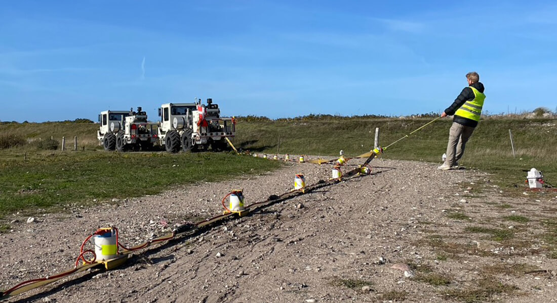
An important component of a geophysics education is to understand where the data comes from. The courses typically include field components that offer hands-on work with different instrumentation needed in geophysics. In addition, in collaboration with GEUS there are opportunities for students to be involved in field programs both onshore and offshore.
Geophysics taught outside the Geophysics Research Group
In addition to the courses listed above, several other relevant courses are taught at University of Copenhagen, especially the Niels Bohr Institute. The Geophysics research group strongly encourages students’ efforts in creating the best geophysical curriculum from their own perspective.
The courses can be found at kurser.ku.dk (search term examples: geophysics*, python*, matlab*)
Student Projects
You can use these descriptions to get inspiration for you own MSc thesis project. You are always welcome to come by our offices and discuss your thesis ideas, whether or not the topic is included in the list.
Many students choose their thesis subject before the middle of June. The formal project period runs from August to May, but some students informally begin fieldwork before August.
Link to the thesis contract page on KUnet: MSc in Geology-Geoscience - Thesis.
- Seismic refraction data analysis: Modeling seismic data to determine subsurface seismic velocities and interpret them in a geodynamic context. Data are available from Greenland, the Arctic Ocean and CCS-related seismic data acquisitions in Denmark. Possibilities for participation in marine fieldwork.
Contacts: John R. Hopper, hopper@ign.ku.dk, GEUS: Thomas Funck, tf@geus.dk, Tanni Abramovitz, tanab@geus.dk - Seismic reflection processing and interpretation: Learn the fundamentals of producing interpretable seismic sections from field data.
Contacts: John R. Hopper, hopper@ign.ku.dk or Tala Maria Aabø, tala@ign.ku.dk, GEUS: Tomi Jusri, toadj@geus.dk, George Donoso, geado@geus.dk, Tanni Abramovitz, tanab@geus.dk - Geological evolution of Greenland's margins: Extensive publicly available seismic reflection data exists over most of Greenland's offshore shelf. Numerous projects are possible: volcanic history, glacial history, basin development and rifting.
Contacts: John R. Hopper, hopper@ign.ku.dk, GEUS: Paul Knutz, pkn@geus.dk, Ulrik Gregersen, ug@geus.dk - Geological evolution of Danish North Sea: Extensive publicly available seismic reflection data and well log data is available over most of the Danish North Sea. Numerous projects are possible: glacial history and evolution, reservoir properties of potential CCS site, stress observations and history from well bore data.
Contacts: John R. Hopper, hopper@ign.ku.dk, Tala Maria Aabø, tala@ign.ku.dk, Lars Ole Boldreel, lob@ign.ku.dk, GEUS: Deep: Tanni Abramovitz, tanab@geus.dk, Ulrik Gregersen, ug@geus.dk, Shallow: Paul Knutz, pkn@geus.dk - Geological evolution of Danish Onshore: Although not as extensively covered as the offshore database, seismic and well log data is available in several areas onshore Denmark. Possible projects include basement mapping for noble gas exploration, regional interpretation of the Sorgenfrei-Tornquist Zone. Integrating the interpretations with gravity and magnetic data is also possible.
Contacts: Tala Maria Aabø, tala@ign.ku.dk, Lars Ole Boldreel, lob@ign.ku.dk, GEUS: Ulrik Gregersen, ug@geus.dk, Tanni Abramovitz, tanab@geus.dk - Magnetic and Gravity methods to develop 3D geological models in Greenland: Projects involving use of potential field data to develop subsurface models consistent with exposed surface geology based on photogeology and hyperspectral imaging are also possible.
Contacts: John R. Hopper, hopper@ign.ku.dk, GEUS: Björn Heincke (gravity, magnetics) bhm@geus.dk, Sara Salehi (hyperspectral), ssal@geus.dk, Erik Vest Sørensen, evs@geus.dk, Pierpaolo Guarnieri, pgua@geus.dk - Plate reconstructions and paleogeography of the Arctic and North Atlantic: The Cenozoic and Mesozoic development of the North Atlantic and Arctic regions has many unanswered questions. Opening of oceanic gateways, vertical and horizontal motions of key areas, and many other projects are possible using Paleostrip, Gplates, and other tools.
Contact: John R. Hopper, hopper@ign.ku.dk - Ambient noise tomography in Greenland. Seismic imaging techniques using ambient noise rather earthquakes or active sources have been developed in over the last few years. Greenland is particularly a good place to apply these methods due to all the natural noise produced by glacial processes.
Contact: John R. Hopper, hopper@ign.ku.dk, GEUS: Aurélien Mordret, aurmo@geus.dk - Earthquake Seismology: GEUS maintains the national seismic network in Denmark and Greenland and there is much data available. Possible projects include deriving focal mechanism for specific events, studying unusual earthquake swarms in Greenland, etc.
Contact: John R. Hopper, hopper@ign.ku.dk, GEUS: Trine Dahl-Jensen, tdj@geus.dk, Aurélien Mordret, aurmo@geus.dk
Ongoing Research Projects
- Linking contemporary plate motions to giant earthquakes
The opening of the South Atlantic is a prime example of present-day oceanic basin expansion. Recent tectonic reconstructions of the region feature highly resolved plate motion changes, which necessarily reflect temporal variations in the field of forces acting upon these plates. These estimates provide valuable insight into the timing and magnitude of grand scale geological processes. Such processes may be shallow- or deep-seated, thus involving plate margins, asthenospheric flow, or the deep-mantle structure. This project aims at studying the kinematics of tectonic plates and the large-scale structure of the underlying mantle, to provide insights into the main controls of plate motion dynamics.
Funding: DFF; Contact: Giampiero Iaffaldano, giampiero.iaffaldano@unipr.it; Valentina Espinoza, vf@ign.ku.dk - History and dynamics of Greenland vertical motion and heat flow
This research aims to disentangle the role of convective heat transport in Earth’s mantle (mantle convection) in controlling the surface-motion history of the North Atlantic region. This is done through an interdisciplinary approach which involves (1) computational modeling of mantle/lithosphere dynamics, and (2) data integration with publicly available geophysical & geological observations.
Funding: Geocenter Danmark; Contacts: Ray Wang, zhirui@ign.ku.dk; John R. Hopper, hopper@ign.ku.dk - Seismic acquisition, processing and modeling in relation to onshore CCS-planning
Geological CO2-storage is important for mitigating climate change. However, this is a rather new task; the first five onshore CO2-storages are under exploration and planning in Denmark, and have to be monitored in the future. Reflection seismic is a key method for these tasks. It is well established method for other purposes, yet a number of questions raises in relation to onshore CCS:
How do we acquire good quality seismic data under a reduced budget, with little environmental impact, through populated areas?
How do we optimally process crooked-line seismic data?Under different circumstances, to what extent can we map CO2 plumes with seismic methods?
This research aims to answer these questions. Funding: GEUS; Contacts: Maiken Lykkebo Olsen, mlo@ign.ku.dk, Lars Nielsen, larni@geus.dk - SEAMS
SEAMS is a collaboration with colleagues at Aarhus University to investigate the Ammassalik Basin offshore south-east Greenland. The Ammassalik Basin is a sedimentary basin that lies stratigraphically below the flood basalts that were erupted prior to and during the opening the North Atlantic Ocean. Little is known about the Mesozoic history of the SE Greenland margin and the new investigations are intended to document the extent of the basin and identify potential sampling areas for future work.
Funding: Dansk Center for Havforskning, Carlsberg Foundation; Contact: John R. Hopper, hopper@ign.ku.dk - PORO-CLIM and PORO-CLIM II
PORO-CLIM is a collaboration with colleagues at the University of Birmingham and the Dublin Institute for Advanced Studies with funding support from the Irish Petroleum Infrastructure Programme, the Irish Marine Institute, and Eurofleets. The project is investigating the impact of Iceland plume volcanism during North Atlantic opening and the connection between plume volcanism and the Paleocene-Eocene Thermal Maximum, an important analog to the present day CO2 fluxes and global warming. A seismic reflection and refraction survey was carried out in 2021 and in September 2024 and in May 2025, there are follow ups with a sampling and mapping cruise of volcanic ridges possibly related to the early stages of plume volcanism.
Funding: Eurofleets, Petroleum Infrastructure Program, Marine Institute Ireland, and Carlsberg Foundation; Contact: John R. Hopper, hopper@ign.ku.dk - Continental Shelf Project of the Kingdom of Denmark
The Continental Shelf Project (https://a76.dk) is a co-operation between Denmark, Greenland and the Faroe Islands. It identifies the submarine areas surrounding Greenland and the Faroe Islands that meet the requirements for an extension of the continental shelf beyond 200 nautical miles. The project works with geological and acoustical data (bathymetric, seismic, sub-bottom profiler). The project is continuously engaged in the acquisition of new data, in particular in the Arctic Ocean.
Funding: GEUS; Contact: Thomas Funck, tf@geus.dk, John R. Hopper, hopper@ign.ku.dk - DECODE-3D
Society has a growing need for correct and updated knowledge about the subsurface. The subsurface is the key to solve a range of societal challenges i.e. climate change, urbanization, raw materials and the green energy transition etc. The project, DECODE-3D, is a first step towards building a national geological 3D model for Denmark, which will deliver relevant, updated information about the geology to be used when solving critical issues in society.
Funding: Geocenter Danmark; Contacts: Lars Ole Boldreel, lob@ign.ku.dk, Tala Maria Aabø, tala@ign.ku.dk - NORAG
Buried tunnel valleys are prominent geological features in the shallow subsurface of the Danish North Sea. The valleys were formed underneath the ice sheets during the past glaciations as erosional channels cut by pressurized subglacial meltwater that drained towards lower pressures at the glacier front. The orientation and position of buried valleys are not exclusively controlled by processes/mechanisms related to the hydraulic gradient. In NOARG we will study the mechanisms that control the orientation and position of buried tunnel valleys, with emphasis on testing if ice-load-induced reactivation of deep faults has been a controlling or attributing factor to the location and orientation of tunnel valleys. Understanding the mechanisms that control the preferred transportation paths allows us to better predict the presence of tunnel valleys in areas with low seismic data coverage. This can be done through informed extrapolation from data points, using geologic depositional models combined with understanding of the preferred erosional paths. We will map and describe all tunnel valleys that can be identified on seismic data and create a database that allows for sorting the different tunnel valleys and highlight possible/potential genetic parameters. These interpretations will be combined with automated fault analyses of deep geological structures to detect causal links. The results from the NOARG project will be highly valuable to offshore engineers and help predict the likelihood of encountering tunnel valleys at offshore construction sites and thus reduce risk and desk study expenses. The project is also expected to provide important new knowledge on the – still debated - genetic processes that form these spectacular geological features in the subsurface
Funding: Geocenter Danmark; Contacts: Lars Ole Boldreel, lob@ign.ku.dk, Tala Maria Aabø, tala@ign.ku.dk
We collaborate with many national and international partners, including:
- GEUS Geophysics and Sedimentary Bains
- GEUS Geoenergy and Storage
- GEUS Near Surface Land and Marine Geology
- GEUS Mapping and Mineral Resources
- Aarhus University Department of Geosciences
- Faroese Geological Survey (Jarđfeingi)
- Center for Planetary Habitability at the University of Oslo
- University of Birmingham
- Dublin Institute for Advanced Studies
- University of Parma
- University of Bedfordshire- School of Computer Science & Technology
- Direktion des Innern des Kantons Zug, Amt für Denkmalpflege und Archäologie
- KANTON LUZERN Bildungs- und Kulturdepartement Dienststelle Kultur Archäologie
- Geopark Det Sydfynske Øhav
Geophysics provides the tools to understand the physical properties and deformation history of Earth's interior that influence other components of the geosphere. At smaller scales, geophysical tools are essential for mapping and understanding structures and fluid pathways relevant to ground water flow, hydrothermal systems, and understanding risks associated with pumping carbon into the ground for long term storage.
Researchers
| Name | Title | Phone | |
|---|---|---|---|
| Search in Name | Search in Title | Search in Phone | |
| Ian Derry Reid | Associate Professor Emeritus | +4535322462 | |
| John Robert Hopper | Professor | ||
| Lars Nielsen | Affiliate Professor | +4535322454 | |
| Lars Ole Boldreel | Associate Professor | +4535322459 | |
| Maiken Lykkebo Olsen | Enrolled PhD Student | ||
| Valentina S Espinoza Fernández | PhD Student | +4535322283 | |
| Zhirui Ray Wang | PhD Fellow | +4535323515 |