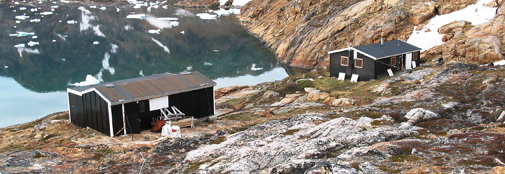
The Sermilik Scientific Research Station
The Sermilik Scientific Research Station provides a logistic base for the ongoing glaciological, hydrological and geomorphological investigations of the Mittivakkat Glacier and its catchment.

Foto: Bent Hasholt
The Sermilik Research Station is located at 65º 40' N and 38º 10'W in South East Greenland about 20 km north of the small town Tasiilaq (Ammassalik). The station is situated at the coast in the Sermilik Fjord on the west side of the island Ammassalik adjacent to a local small ice cap, the Mittivakkat Glacier.
Mean annual temperature: -1.7 ºC
Mean temperature in January: -7.5 ºC
Mean temperature in July: 6.4 ºC
Mean annual precipitation: 984 mm
Mean annual precipitation days: 120
Mean annual sunshine hours: 1374
The environment in the SE sector of Greenland is low arctic maritime and presently experiencing pronounced changes. The regional temperatures, the cyclonic influence from lower latitudes and the impact of the Irminger Current are changing. The region is warming and consequently the Inland Ice and local glaciers are melting back. Increasing amounts of calving ice from Inland Ice outlet glaciers, among these the Helheim Glacier, are influencing the Sermilik Fjord.The vegetation of the area, situated in a low arctic coastal vegetation zone, demonstrates large flora diversity. It is dominated by dwarf shrub heaths, snow bed communities, and open fell-field communities. Fens, herb slopes and copses are present but are only found as smaller niches in the alpine dominated landscape.
The town Tasiilaq, with its approx. 1700 inhabitants of a total population in East Greenland of about 3000, is located 20 km south of The Sermilik Research Station. Tasiilaq is the largest city in East Greenland, and the city is scenically located on the Ammassalik Island at the outer coast in a local fjord surrounded by high mountains. A small river flows through the city. The Ammassalik Island and valleys behind the town have a unique flora and is a popular place for hiking.
Only about 100 years ago, the first Europeans came to the area, and the traditional Inuit culture still has a major role in daily life. But Tasiilaq is also a modern community, and the Internet and mobile phones have reached Tasiilaq. Fishing, hunting, service industries and tourism dominate. In 2004 a water power plant was constructed and put to use. 1,2 MW are produces, covering most of the electricity needed in the town.
Data on plant and lichen performance exist, including the application of lichenometri in dating of glacial deposits.
Data are available on request from:
Three climate stations: at the glacier equilibrium line (515 m.a.s.l. established in 1994)), at the coast (established in 1998) and at about 200 m.a.s.l. (established in 2009), comprising data on Si, temperature, RH, wind (direction and speed) and precipitation.
River stations: established in the mid 1990th in the proglacial valley, close to the glacier front and at the river mouth, comprising data on stage, discharge, temperature, conductivity and suspended sediment concentration.
Glacier mass balance measurements and glacier surveys carried out since the mid 1980th . Delta surveys carried out since 1989.
Maps, digital 3D terrain models, satellite data and aerial photography. Furthermore a bibliography is available, of publications arising from research at The Sermilik Research Station.

Contact
For booking of the Sermilik Station contact:
Aart Kroon, Professor
ak@ign.ku.dk
