Vegetation and climate change in Eastern Africa
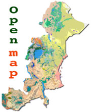
A potential natural vegetation (PNV) map for eastern Africa.
 The PNV map of eastern and southern Africa covers the countries Ethiopia, Kenya, Uganda, Rwanda, Tanzania, and Zambia.
It is the product of the project Vegetation and climate change in Eastern Africa (VECEA).
The VECEA project is a collaboration between various partners in east Africa and Europe. The project was funded by a grant from the Rockefeller Foundation.
The potential vegetation map is available as a Google Earth layer. You can open the layer by clicking the image to the right. (If you don't have Google earth, please download it first - you can download it from earth.google.com).
URL to the vegetation map
http://vegetationmap4africa.org/2_Vegetation_map.html
Website for the Potential natural vegetation of eastern Africa
We have dedicated a website for further development of tools and utilities based on the map.
Species selection tool
A species selection tool based on the VECEA map shows the useful tree species for Eastern Africa.
Documentation
An 8 volume series documents the potential natural vegetation map developed by the VECEA project.
Free download: 8 volume series: Potential Natural Vegetation of Eastern Africa
Contact
For further information, or comments, please contact
Paulo van Breugel, p.vanbreugel.com@gmail.com or
Jens-Peter Barnekow Lillesø, jpbl@ign.ku.dk.
The Rockefeller Foundation
The project was supported by the Rockefeller Foundation.

